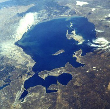
The Aral Sea has shrunk due to the diversion of its source rivers (2022)
It was shocking when researchers revealed earlier this year that a river originating from one of Canada's largest glaciers abruptly disappeared over four days in 2016. The disappearance of the Slims River, however, was the result of global warming as the intense melting of the glacier led the river to redirect its waters into the Gulf of Alaska.
But, the Aral Sea, similar to the river in Canada, was known as "one of the worst environmental disasters on the planet" due to human interventions more than geographical and climatic changes. Once the fourth largest lake in the world, called the sea because of its size, it has now shrunk by more than 90% of its size over fifty years ago, mainly due to the diversion of its source rivers.
>Table of Contents
Location and history of the Aral SeaLocated between Kazakhstan to the north and Karakalpakstan, an independent region of Uzbekistan, to the south is the Aral Sea. The Sea of Islands referred to the existence of over 1500 islands as a wonder in itself. The two rivers that feed the Aral Sea are the Amu Darya and Syr Darya rivers, where the former reaches the body of water from the south, while the latter reaches from the north. According to the map of a Greek scholar Claudius, then the Caspian and the Aral Sea were joined and formed a vast inland sea earlier.
However, according to geographer Dr Nick Middleton, the Amu Darya did not sink to create the Aral Sea until the onset of the Holocene, and it was flowing into the Caspian Sea until then. He also noted that the Syr Darya led to the formation of a large lake called the Mynbulak Depression in the Kyzyl Kum during the Pliocene.
The Aral Sea region is characterized by a continental desert climate, hot summers, cold winters and scarce rainfall, only 100 mm per year.
Beginning of the disasterAccording to historical records, the Aral Sea region was inhabited by desert nomads and served to support a booming fishing industry in the region. In the 20th century, the Aral Sea was considered the fourth largest inland water body in the world, with an approximate area of 68,000 km2. Additionally, the rivers that fed the lake also offered water to nearby towns, giving rise to the historic Silk Road.
However, it was not until the 1930s that the Aral Sea disaster began to take shape. With the increase in agricultural land to further enhance the thriving cotton industry, water consumption has also increased dramatically. Following the Soviet government's plan to irrigate the desert by undertaking a diversion project to cultivate rice, melons, cereals and cotton, many dams and irrigation canals were built on the arteries of the sea of Aral. Moreover, the poorly constructed canals have also led to wastage of water at a severe level. The water wastage of the largest canal in Central Asia, the Qaraqum Canal, is said to have been 30-70%.
In the 1960s, the water level of the Aral Sea dropped dramatically, with up to 60 cubic kilometers of water going to farmland instead of the sea. increased as cotton production on farmland doubled between 1960 and 2000. As a result, sea shrinkage occurred at a maximum rate, averaging 20 cm per year between 1961 and 1970, 50 -60 cm in the 1970s and 80 to 90 cm in the 1980s. The latest data reveals that the water level in the Aral Sea is falling by an average of 31 to 35 inches per year.
In line with the reduction in water level, the area of the sea also decreased by about 60% between 1960 and 1998. While the Aral Sea had an area of about 68,000 km2 in 1960 , the area recorded in 1998 was 28,687 km2. Its position among the largest lakes also rose from fourth to eighth during this period. In 1987, the continuous shrinkage caused the Aral Sea to split into two parts. The North Aral Sea was the smallest part (known as the Little Sea), and the South Aral Sea became the largest part of the lake (the Great Sea).
Damaged ecosystem and danger to human healthDespite the geography...
What's Your Reaction?